Stockyard
Gully Caves.
Distance from Perth: Perth to Stockyard Gully Caves 280km, Perth to Lake Indoon via Stockyard Gully 305km, Perth to Lesueur National Park 240km.
Nearest fuel: Eneabba Roadhouse 12 km from Lake Indoon or Leeman 25km from Lake Indoon.
Add a distance of 10 km form the Caves to either fuel stop.

On
this trip there are 3 places to visit, The Stockyard Gully Caves, Lesueur
National Park & Lake Indoon.
This part of W.A. could be combined with a trip to Wedge Island, Cervantes,
Jurien Bay or even Lancelin.
(When we did this trip, we combined it with a trip to Cervantes with spending
time at sand dunes near Wedge Island and the Pinnacles just south of Cervantes
and staying overnight at Cervantes Caravan Park.
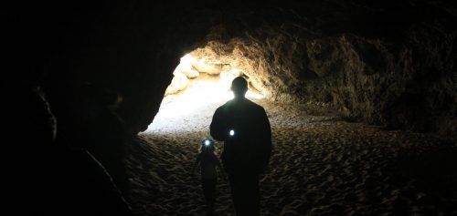
In Stockyard Gully national park there are ancient underground river systems, one of them is now a cave that's about 300m long which snakes through lime stone rock. To get to the cave entrance you must walk through a valley that's been carved by river over the centuries.
The river is no longer there however take care during heavy rains as the cave has been flooded in recent times, 1999 was the latest mayor flood. When flooded the cave is too dangerous and will be inaccessible.
In this area there are heaps of feral bees that have hives clinging to the rock
faces, which is quite a sight to check out. Take care not to threaten the bees.
Nearest camp site to the caves is Lake Indoon.

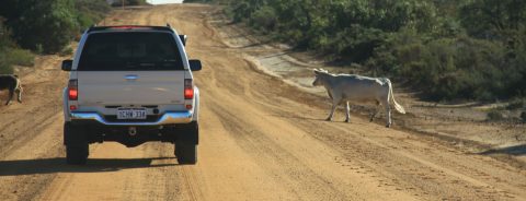
Escaped
cattle on Stockyard
Gully Road.
To
get to Stockyard Gully National Park from the south, head north on Cockleshell
road this starts as a T junction from Jurien road. Keep an eye out for escaped
cattle, as it's not uncommon to have a cow or two wandering around the road. On
the way to stockyard gully you will pass Lesueur National Park which is worth
visiting (see Lesueur National Park).
Continue to follow Cockleshell road until it ends and becomes a sand track, this will be a dead end for 2wds (it's quite obvious when the road ends and the track starts). At this point stop and deflate tyres to suit the sandy conditions ahead (even if traction is ok with road pressures you will still need to deflate to protect the tracks from being carved up).
From here follow the main track north and this will lead you to the Stockyard Gully Caves, there are a few signs on the way to help give directions.
Lesueur National Park:
The
national park covers an area of just under 27,000 hectares.
The entrance is an 18km one-way road which straddles Cockelshell road. There
are 3 main parking areas with great views of the landscape.
There are a few bush walk tracks, one of which takes you to the top of Mt
Lesueur (a big Plato), from which the ocean can be seen.
Best
time to visit the park is in spring as all the wild flowers are in full bloom.
Park
entry $11.00
There are no camp sites in this area.
SEE ALSO 4 WHEEL DRIVE SAFETY TIPS.
Lake
Indoon:
Lake Indoon is north of the Stockyard Gully caves. Head north on the sand track from the caves for about 9km and then take a left at Coolimba Eneabba Road (heading east), from there it's about a 5km drive until you will reach Lake Indoon. Here you can enjoy water sports or just relax by the lake (no jet skis are allowed).
Overnight camping fees are $10.00 per adult and children 16 & under are $3.00
There
is a total fire ban all year round, but there are gas BBQ's available.
For more info contact the Shire of Carnamah office on :0899517000
Things to do:
Track conditions and difficulty:
Very Easy:
Most of this trip is on well maintained gravel roads, the track to Stockyard Gully
is 4WD only and 20-25 PSI is recommended to avoid chewing up the track.
The one way road to Lesueur National Park is black top.
What to bring:
Air compressor, sunscreen, bush hat, plenty of water & food, shovel, rated recovery gear, CB radio tools, boat or other water sport devises for Lake Indoon & camping gear.
Best time to go:
All
year round. In spring the wild flowers are blooming.
GPS way points:
|
For information about How to enter the GPS Way-points into Google Earth see this video. |
For information about How to enter the GPS Way-points into Google Earth
see this video.
Cockleshell
road T junction of Jurien road:
|
Latitude: |
Longitude:
|
Entrance
to Lesueur National Park (one way):
|
Latitude: |
Longitude: |
Lesueur National Park main car park:
|
Latitude: |
Longitude: |
End
of Cockleshell road and start of Stockyard Gully sand track:
|
Latitude: |
Longitude: |
Stockyard Gully Caves:
|
Latitude: |
Longitude: |
Start of
track leaving caves, heading north to Coolimba Eneabba rd (towards Lake
Indoon):
|
Latitude: |
Longitude: |
Coolimba
Eneabba rd (head east from here towards Lake Indoon):
|
Latitude: |
Longitude: |
Lake
Indoon:
|
Latitude: |
Longitude: 115° 9'20.84"E |
Recent Articles
-
Goodyear wrangler MTR
Jun 28, 24 10:27 PM
I have these on my defender 90 and my Dmax Ute. I get around 100,000 km out of them. I tried AT for one change and went back to the MTs. They are gol -
4x4 off road tracks 0 to 250 km from Perth
Nov 21, 23 07:40 PM
On this page we cover 4x4 off road tracks within a 250 km radius from Perth... -
4 Wheeling Around Jurien Bay.
Nov 21, 23 07:35 PM
Jurien Bay 4x4 tracks info and general information about the area...
- Home
- 250-500km From Perth
- Stockyard Gully Cave
Leave Stockyard
Gully Cave And Go To 4-Wheeling-in-Western-Australia.


