GPS Waypoints
For The Peaceful
Bay Area.
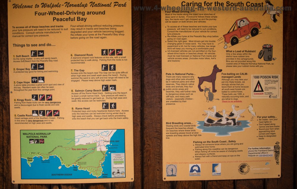
The Peaceful Bay area is located along the south west coast of Western Australia. The area offers you great beaches, 4 wheel drive tracks and fishing spots.

Info Airdown Station Peacefulbay.
For your information we have provided you with GPS Waypoints for some places of interest when you visit the this area on your next holiday or 4 wheel drive adventure.
GPS Waypoints.
|
For information about How to enter the GPS Way-points into Google Earth see this video. |
For information about How to enter the GPS Way-points into Google Earth
see this video.
Peaceful Bay:
|
Latitude: 35° 2'29.76"S |
Longitude: 116°55'45.78"E |
Rame Head track:
Rame Head Tracks entrance:
|
Latitude: 35° 2'19.26"S |
Longitude: 116°55'21.22"E |
Salmon Beach Camps:
|
Latitude: 35° 2'51.71"S |
Longitude: 116°52'40.13"E |
Salmon Beach Access:
|
Latitude: 35° 2'52.79"S |
Longitude: 116°52'46.99"E |
Rame Head:
|
Latitude: 35° 2'34.36"S |
Longitude: 116°51'0.00"E |
Peaceful Bay Southern track:
Peaceful Bay Southern Tracks entrance:
|
Latitude: 35° 2'26.62"S |
Longitude: 116°55'26.80"E |
The Gap (beach access):
|
Latitude: 35° 3'16.99"S |
Longitude: 116°54'11.75"E |
The Gap exit (takes you onto the continuing tracks):
|
Latitude: 35° 3'23.17"S |
Longitude: 116°54'23.22"E |
Diamond Rock (lookout):
|
Latitude: 35° 3'40.52"S |
Longitude: 116°54'57.71"E |
Castle Rock:
|
Latitude: 35° 3'42.29"S |
Longitude: 116°55'14.27"E |
Kingy Rock:
|
Latitude: 35° 3'41.76"S |
Longitude: 116°55'29.00"E |
Cape Hope:
|
Latitude: 35° 3'29.09"S |
Longitude: 116°55'30.38"E |
Gropper Bay Beach:
|
Latitude: 35° 3'11.03"S |
Longitude: 116°55'29.60"E |
Soft Beach (the exit, please take note of the beaches name):
|
Latitude: 35° 2'54.08"S |
Longitude: 116°55'42.29"E |
Recent Articles
-
Goodyear wrangler MTR
Jun 28, 24 10:27 PM
I have these on my defender 90 and my Dmax Ute. I get around 100,000 km out of them. I tried AT for one change and went back to the MTs. They are gol -
4x4 off road tracks 0 to 250 km from Perth
Nov 21, 23 07:40 PM
On this page we cover 4x4 off road tracks within a 250 km radius from Perth... -
4 Wheeling Around Jurien Bay.
Nov 21, 23 07:35 PM
Jurien Bay 4x4 tracks info and general information about the area...
- Home
- 250-500km From Perth
- Peaceful Bay Area
Leave Peaceful Bay Area And Go 4 Wheeling In Western Australia.


